
Geographic Information Science (GISc) is a field of study that covers a range of socio-political, geographical and informational disciplines. It involves the use of various technologies for recording and analyzing spatial and geographic data in a useful and easily-accessible manner. Using computer-based applications, GIS frameworks allow engineers and technicians to create interactive queries from collected data and produce visually compelling data maps.
While the sector is highly specialized and relatively unknown outside of those involved, many citizens interact with GIS products daily. GIS concepts are used by a wide range of industries, including logistics, transport, insurance, telecommunications, planning and management. In particular, the global pandemic has created many opportunities for GIS technology to shine, providing a means for governments to better monitor population movements, address inequalities and accelerate recovery efforts.1
Important Developments in GIS
With new developments in 3D mapping, real-time analysis and powerful sensor technology like Light Detection and Ranging (LiDar), 2021 looks set to be a groundbreaking year for individuals working in GISc. Read on to discover some of the most important developments that geographic information scientists are working on.
1. Healthy Competition Over Climate Change
Several scholars and experts have recently begun to voice the opinion that the US should compete, rather than cooperate, with other countries over climate change. This is based on the belief that international trade negotiations will favor countries that achieve their climate change goals and this healthy competition will incentivize a more urgent response in less proactive nations.
GISc solutions can help scientists to create better visual models of global energy consumption, helping them to plan and implement sustainable programs. Potential areas where GIS technology could help include reforestation, heat vulnerability, rising oceans and alternative energy implementations. By using GIS software to combat these issues, scientists can help us meet our climate change goals and prompt other nations to follow. 2
2. Mapping COVID-19 Recovery
When the COVID-19 pandemic first hit, organizations around the world scrambled to make sense of the outbreak and provide meaningful information. To meet the demand, a team from the John Hopkins University used GIS software developed by the Environmental Systems Research Institute (ESRI) to create the first widely-used pandemic information reference database. 3
Having undergone several iterations since, the map now updates with statistics from some of the world’s leading health metric providers such as the WHO, CDC, ECDC, and various governmental agencies. Data available includes the total number of reported cases, reported cases per country, active cases, deaths and recoveries. Data is mapped by geocoding and represented by the size of a circle at the center of each region. The level of spatial detail varies depending on the available data from each country but is improving daily. 4
3. Real-time Sensor Data
GIS provides a solution to several industries and government departments that use manual checks to ascertain conditions, such as water and power utilities, farming and medical. With GIS solutions integrated into existing asset management systems, organizations can save considerable time and money spent on human surveillance.
Information from the Global Positioning System (GPS) can also be fed into GIS software to automate the tracking of assets, further reducing overhead costs. Recently, several organizations have begun using miniature drones with attached sensors to track operations or collect sample data. GIS software can receive and process this data in real-time, providing powerful applications for military and aeronautical industries.5
4. Equity and Social Justice
One unlikely but incredibly useful tool that has surfaced as a result of GIS integrations is the ability to map and expose oppression and inequality in specific regions. Specifically, concerning COVID-19 recovery efforts, GIS mapping has been particularly successful in highlighting communities disproportionately affected by the pandemic.6
In the US, data from GIS mapping reveals that Black and Latinx communities have experienced more deaths and positive cases as a result of historically inequitable policies. Equity and social justice (ESJ) work is guided by the GIS Code of Ethics, designed to help professionals in the sector make well-informed and appropriate choices.7
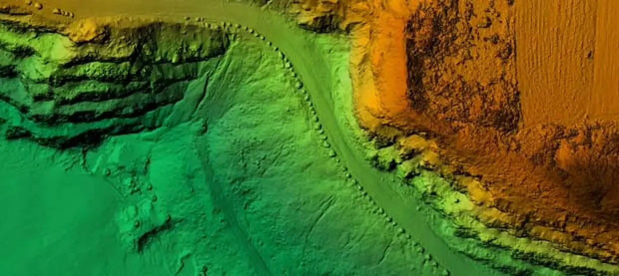
5. LiDAR
Light Detection and Ranging (LiDAR) technology is one of the most widely-used applications of geospatial technology. Similar to how sonar measures the ocean floor, LiDAR uses a pulsing laser to measure variable distances and create a 3D map of any area on Earth. Developed by NASA over 40 years ago, LiDAR has only recently become small enough and affordable enough for commercial usage.8
In the progression of autonomous driving vehicles, LiDAR has proven particularly beneficial by providing a method to measure the exact size and distance of objects. Hollywood filmmakers have been known to use LiDAR to scan and digitally recreate famous landmarks that are otherwise prohibited for commercial use. 9
LiDAR is similar to RADAR in that it receives information at the speed of light, unlike Sonar which uses sound waves and is much slower. LiDAR is a newer and more expensive technology than RADAR, using a shorter wavelength to build more detailed and complex 3D models.10
Enact Positive Change in the World
GIS technology is being adopted by a range of industries and professionals who focus on reducing inequality, highlighting social injustice and improving climate change policies. If you’re interested in a dynamic career that could help make the world a better place, an online Master’s in Geographic Information Science from Kent State University could be a good fit for you. Speak to an advisor today about our comprehensive online MGISc course, developed by NOAA grant-winning professors with real-world experience in the industry.
Sources:
- Retrieved on May 27, 2021, from josis.org/index.php/josis/article/view/32
- Retrieved on May 27, 2021, from esri.com/content/dam/esrisites/sitecore-archive/Files/Pdfs/library/bestpractices/climate-change.pdf
- Retrieved on May 27, 2021, from esri.com/about/newsroom/arcuser/gis-systems-lead-response-to-covid-19/
- Retrieved on May 27, 2021, from gislounge.com/this-map-is-tracking-the-novel-coronavirus-in-near-realtime/
- Retrieved on May 27, 2021, from ij-healthgeographics.biomedcentral.com/articles/10.1186/1476-072X-14-2
- Retrieved on May 27, 2021, from mappingcovid19equity.org/
- Retrieved on May 27, 2021, from gisandyou.org/2020/12/17/gis-for-equity-social-justice-training-in-2021/
- Retrieved on May 27, 2021, from mynasadata.larc.nasa.gov/stem-career-connections/technology-lidar-remote-sensing
- Retrieved on May 27, 2021, from lidarmag.com/2015/06/05/as-lidar-goes-to-hollywood-hypevr-and-velodyne-are-deep-in-3d/
- Retrieved on May 27, 2021, from https://archer-soft.com/blog/lidar-vs-radar-pros-and-cons-autonomous-driving


